
Eldora, Colorado--popularly known as Boulder's closest ski area--is one of several gateways into the stunning Indian Peaks region of Colorado. Fourth of July and Hessie Trailheads are the two main trailheads into this part of the wilderness, accessing numerous jagged peaks and subalpine lakes in the Middle Boulder Creek drainage. The upper tier of these lakes requires significant effort to access, but two of them--Diamond Lake and Lost Lake--can be reached by trails of moderate length and steepness.
 |
| Beautiful Diamond Lake |
The road to Eldora departs westward from the Peak to Peak Highway at the south end of Nederland, 0.6 miles south of the Highway 119/72 roundabout. Stay right at the fork to the ski mountain, and continue through the small town of Eldora. The Hessie Trailhead is at 4.8 miles and the Fourth of July Trailhead is 4 miles further up a bumpy, unimproved road.

Location Info: [key]
(Diamond / Lost)
Scenery: 5 / 4
Shoreline Interest: 3 / 2
Use: High
Fee: None
Full elev = 10950 / 9800
Shoreline Interest: 3 / 2
Use: High
Fee: None
Full elev = 10950 / 9800
Access (Diamond):
Rough 2WD Dirt + 2.5 mi. hike
Eldora/Hessie Shuttle
The area's proximity to Boulder and Denver make it very popular in the summertime. In fact, the limited parking space at both trailhead has prompted Boulder County to implement a hiker shuttle on busy summer weekends. When parking at each area reaches capacity (only a few dozen vehicles at Fourth of July and maybe double that at Hessie), the town closes the roads to inbound traffic. The shuttle operates out of the Nederland High School parking lot and transports hikers to the Hessie trailhead. However, there is no access to Fourth of July after parking fills up, which can be very early in the morning on summer weekends.
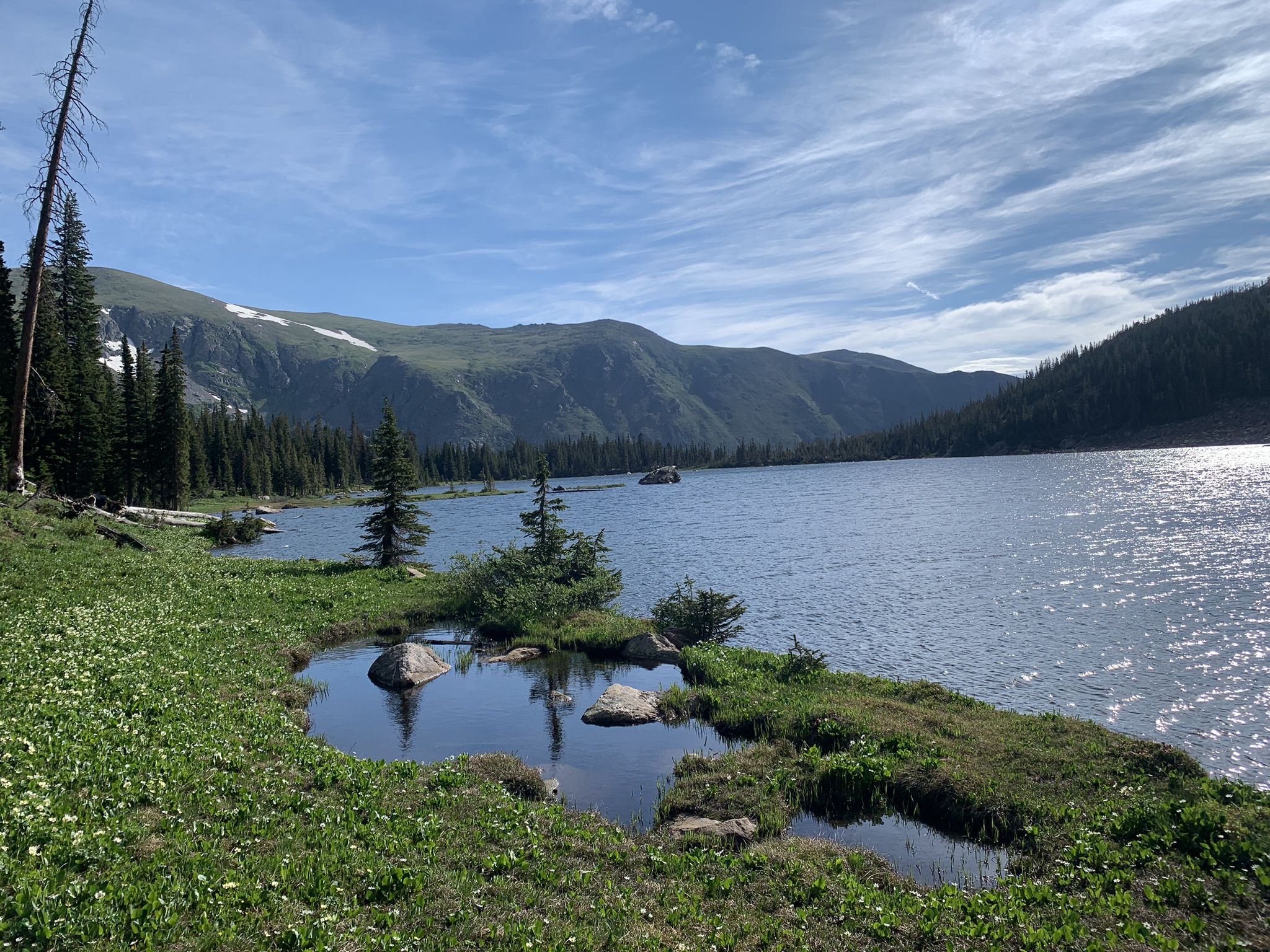
Diamond Lake

Kite-shaped Diamond Lake is a rewarding place to paddle in July or August. Its lush surroundings, inviting shallows and panoramic views give it a unique enchantment that sets it apart from its neighbors. Unlike the many glacial cirque lakes in the area, Diamond Lake is perched above Middle Boulder Creek on an elevated bench. This gives it beautiful vistas across the valley toward Arapaho Peak as well as up the rugged ridgeline behind the lake. A trail accessing backcountry campsites follows the northwest shore of the lake. If there is a west wind, which is not uncommon at this altitude, the far end of the lake might be the best place to put in. Diamond Lake is surprisingly shallow along the shoreline; be aware of rocks just beneath the water surface.
 |
| First view of Diamond Lake from trail |
The route to Diamond Lake from Fourth of July Trailhead follows Arapaho Pass Trail northwest for 1.1 miles to the Diamond Lake Trail junction, climbing moderately en route. From the junction, the Diamond Lake Trail descends 0.5 miles to Middle Boulder Creek, does a U-turn, and climbs one more mile up the opposite side of the valley to the Diamond Lake. From a trail map, the path to Diamond Lake may appear excessively circuitous, but the trail deliberately routes around private property beyond the Buckingham Campground at the trailhead. However, it's easy to keep an eye on the destination. Look for the prominent cascade on the opposite side of the valley, which becomes visible through the trees just before the wilderness boundary sign. That cascade is Diamond Lake's outlet stream, and the lake itself is just beyond.
 |
| Diamond Lake |
 |
| Lost Lake |
Lost Lake
Similar to Diamond Lake, Lost is a mid-valley lake that is perched on the side of the basin below. Consequently, it is a much shorter hike than the string of cirque lakes beneath the Continental Divide at the head of the watershed. Lost Lake is lower in elevation and more compact than Diamond, with a forested shoreline. Its views are less expansive but still very beautiful. Lost is also better protected from wind than Diamond.
 |
| Lost Lake in the fall |
The route to Lost follows the Devils Thumb Trail for 1.6 miles westward from the Hessie Trailhead, then 0.3 miles southward on the Lost Lake Trail. There are intermediate junctions for Devils Thumb Bypass Trail (at 1.3 miles from the trailhead) and Old Lost Lake Trail (at 1.7 miles), but staying left at every signed intersection will get you to Lost Lake.
Other nearby lakes
The Indian Peaks and James Peak Wilderness areas have a LOT of high mountain lakes. For the adventurous, many more lakes in the Middle Boulder drainage can be accessed on foot. These include Woodland, Jasper, Skyscraper, and Devils Thumb lakes from the Hessie Trailhead and Dorothy Lake from Fourth of July.
 |
| Diamond Lake; view to northeast |
Three more lakes--King, Betty and Bob--live at the top basin, right beneath the continental divide. These lakes are 6 miles up from the Hessie Trailhead, which is a long way to carry an iSUP. They are all, however, within two miles of the Rollins Pass Trailhead, which is accessible by motor vehicle from the Winter Park side. These lakes and a couple others will be featured in a future post covering the western approach of the Rollins Pass Road.
 |
| Abundant paintbrush in the Indian Peaks |
 |
| Rey Skywalker, with her namesake couloir beyond |
The next drainage to the south, South Boulder Creek, has plenty more beautiful sub-alpine lakes. These can be explored from the eastern side of Rollins Pass Road. The watershed beyond--Fall River--has another cluster of lakes accessible by four-wheel-drive. And eight miles north of Diamond and Lost is the stunning Brainard Lake Recreation Area. Lastly, the roadside lake just before the entrance to Eldora ski area is called Peterson Lake. It is located on private property and is not open to public recreation.
Diamond and Lost Lakes are cold, high-elevation waters that can harbor ice into July. Summertime thunderstorms can roll in with little warning, often with strong winds, very cold rain or even hail. Check the text forecast and the hourly forecast to get an idea of weather risk and timing before heading out. Both lakes are places to wear your PFD, rather than just strap it to the board.
 |
| Diamond Lake; view up-valley |
The hiking trails that lead to Diamond and Lost may be popular, but they are still in the wilderness and somewhat remote. Cell service is sparse. Sturdy footwear is important, as is good judgement. Bears and moose live here too, so bear repellent spray is a good idea if you have it. Also, dogs must be leashed within the wilderness boundary.
The Indian Peaks is one of Colorado's special places, and a sublime setting to absorb by SUP. Diamond and Lost Lakes are both stunning destinations with a highly satisfying effort-to-reward balance. Plan for a weekday, start early, use good judgement and wear a PFD!
No comments:
Post a Comment