
Deep and narrow Morrow Point Reservoir is the central of the three lakes in the Curecanti National Recreation Area. It begins immediately downstream of Blue Mesa Dam. But unlike the highly visible Blue Mesa Lake, Morrow Point cannot be seen from U.S. 50 and is only visible from a few locations on State Highway 92--both of which run less than a mile from the lake. The hidden nature of the lake and the moderate effort required to reach the water make Morrow Point one of the best stand-up-paddle surprises in Colorado.
 |
| Morrow Point Reservoir |
Access
Accessing Morrow Point requires hiking down about 180 vertical feet from the Pine Creek Trailhead in the Curecanti Recreation Area. The Pine Creek Trail, which is also serves guests of boat tours run by the park service, is well-constructed and consists of about 230 stairs to descend to the Gunnison River. The flow of the river might appear fast or turbulent when it first comes into view. The gradual transition of river flow to still lake water occurs over the next half-mile. It will likely be necessary to hike some of all of this distance along the trail paralleling the river to find a suitable launch point. River flows can change quickly in this stretch, and there are some protruding rocks that create whitewater conditions. It's best to launch after the tour boat dock becomes visible to avoid surprises.
 |
| Vicinity Map |
Scenery: 5
Shoreline Interest: 5
Use: Low-Moderate
Fee: None
Access: Gravel + 0.5 mi, 200' vert hike down
Full elev = 7160; Best above 7153;
The narrow gorge descended by the Pine Creek Trail is the uppermost reaches of the Black Canyon. As the Gunnison River flows west, the chasm cuts deeper and deeper, with the narrowest and deepest section being protected within the Black Canyon of the Gunnison National Park.
 |
| Cliffy shoreline of Morrow Point Reservoir |
Water level and inflow conditions
Lake elevation and river flow are important features to understand before attempting a paddle trip on Morrow Point. The lake's elevation historically hasn't varied much below the full elevation of 7160. But since the launch point is at the river inlet, small variations can make a big difference in the lake inlet's conditions. USBR has real-time data of water operations, but it takes a little bit of navigation:
 |
| The USBR water database link opens a map; find and click on Morrow Point. "Inflow" and "Pool Elevation" are among the properties listed on the left side. |
As the elevation of the incoming riverbed descends below the lake's water surface elevation, resistance to the river current develops. However, the resistance to flow builds gradually and can take a few thousand feet of distance before the river's velocity is substantially dissipated into the lake's still waters. The higher the lake elevation, the farther upstream the transition begins to occur. But higher river flows means greater velocity and longer distance that the current will persist into the lake.
 |
| The median pool elevation throughout the year is about 7154, but take precautions if the water elevation is more than a few feet below that. |
Generally, the combination of a higher lake elevation and lower river flows make the best launch/takeout conditions. The lowest flows usually occur during the winter, but early June seems to be a good window in the warmer months. The most applicable flow parameter for the Gunnison River inlet is properly the Blue Mesa Dam release flow, but the published inflow value for Morrow Point will reflect this reasonably closely.
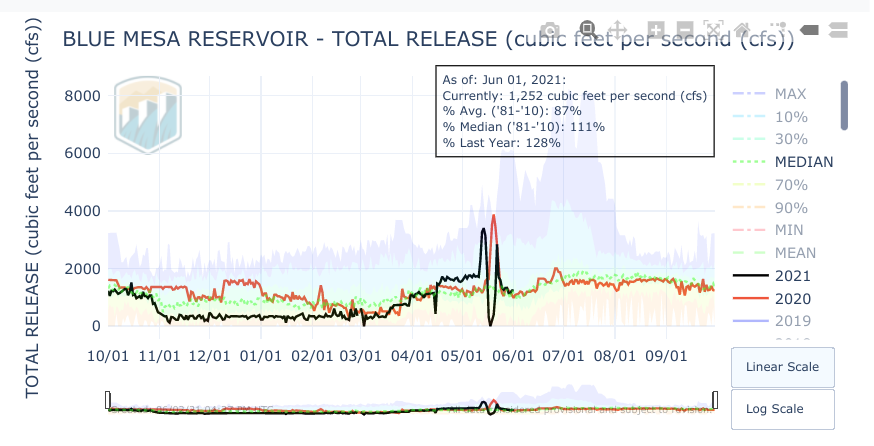 |
| Median release flows from Blue Mesa for early June are about 1200 cfs, and are typically lower than later in the summer. Mid-may can see very large spikes in realease for recreational whitewater flows downstream |
The photos in this post correspond to a water level of 7156 and a river flow of about 1250 cfs, which proved to be an accommodating combination for launching higher up in the Gunnison River inlet. There is not distinct nor constant location where the river ends and the lake begins. However, some aerial imagery shows the presence of whitewater-creating rocks in the riverbed downstream of the boat dock, which would emerge in lower water level conditions. Because of the uncertainty of predicting how these two parameters will interact, we can't recommend touring Morrow Point by paddleboard with water elevation much below 7152 or a flow above 1500. If you visit outside of--or even within--this range, feel free to post a comment on the ease of navigation by paddleboard and the corresponding water level and flow conditions of that date.
 |
| Pine Creek Trail stairs |
 |
| Boulders in the Gunnison River inlet |
Features
Once past the dock and the end of the hiking trail, the lake continues into the narrow canyon. Both banks alternate between steep slopes and near-vertical cliffs, creating series of dramatic gateways with cliffs on both sides. Depending on water level, there may be a few rock outcrops poking above the water surface in the first half mile or so. At 1.2 miles past the dock, there is a hidden but audible stream that empties into the lake from the north under talus. At 1.4 miles is a backcountry campsite (Narrows; permit required) on the southern bank. At 2.3 miles, Chipeta Falls tumbles over the north bank into the lake. At 3.2, the impressive Curecanti Needle towers above the south bank at the confluence with Big Blue Creek. The lake continues west a total of 12 miles with a few more backcountry camping sites (permit required) for those seeking an extended adventure.
The commitment level of an adventure in Morrow Point is greater than many other Colorado destinations, so a detailed and repeated assessment of the weather forecast is warranted. The depths of the canyon can protect from breezes in the north-south direction, but has the potential to amplify winds that become aligned to the east-west direction. It can also capture and redirect winds from the NE, NW, SE or SW. Additionally, any bailout points to the west require steep hikes out, and are far from the Pine Creek Trailhead. The cliffs that edge the lake prevent any alternate mode of travel to return to the launch area. Be certain that you can paddle back upwind if the wind picks up or changes direction.
 |
| Morrow Point Reservoir |
 |
| Morrow Point near inlet |
The best forecast to paddle here is a wind speed of 8 mph or less. Also review the hourly forecast chart and text discussion to understand how speed and direction are expected to change as the day progresses. We strongly recommend a two-paddle kayak setup to be prepared for any surprises in wind. The day we paddled here, we lucked out with an intermittent light breeze from the favorable east direction in the morning, then a reversed light breeze from the west direction for the return trip--consistent with that morning's detailed forecast.

 |
| Cumulus clouds above the canyon |
The canyon heights obscure a view of approaching weather until it's almost directly overhead. Most summer days have some chance of precipitation in the forecast, but there is big difference between 20%, which might mean 20 minutes of sprinkles, and 60%, which could be an hour or more of full-on cold rain. There is also a big difference between a forecast of showers--which could be moderate intensity rainfall--and a forecast of thunderstorms--which can also be accompanied by lightning, downpour, hail, and gale-force gusts. Start early to get a jump on the best weather window. If the weather looks questionable, the nearby Lake Fork and Soap Creek areas of Blue Mesa Lake offer good paddling alternatives with much less commitment and risk.
 |
| Canyon walls of Morrow Point |
The high reward of a paddling on a narrow, protected, lightly-visited canyon lake does not come without risks. Again, there are no bailouts out of the canyon, so be certain that you can paddle upwind or up-current back to the Pine Creek Trail. There are also limited places to find shore refuge due to the cliffy terrain. Consider a wetsuit--particularly if the weather is cloudy or cool--as the lake waters are likely cold. Understand your ability and comfort level on the water. Take plenty of food and water, triple-check the water and weather conditions and wear a PFD!
No comments:
Post a Comment