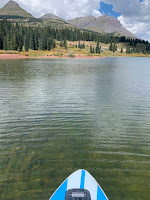
Molas Lake sits placidly along one of the most vista-rich stretches of the Million Dollar Highway.
While the famed Durango and Silverton Narrow Gauge Railroad winds through the treacherous depths of the Animas River Gorge, U.S. 550 elegantly skirts the most rugged terrain via Coal Bank and Molas Passes. An unlikely flat near the top of the pass provides a perched setting for Molas Lake. Two additional lakes--Little Molas and Andrews--offer more paddling options very close by.
Highly visible from U.S. 550, Molas Lake is located 5 miles south of Silverton--just below the summit of Molas Pass. The lake is actually just outside of the San Juan National Forest boundary. It is owned by the Town of Silverton and managed as a town park, open to the general public. The town also operates a campground on the east shores of the lake; the west side is open for day use, free of charge. A small, lakeside store at the campground entrance also offers paddleboard and kayak rentals.
 |
| Vicinty Map |
(Molas / Little Molas / Andrews)
Scenery: 5 / 4 / 3
Shoreline Interest: 3 / 1 / 2
Use: Mod-High / Mod-Low / Mod-Low
Fee: None for day use
Access: Gravel
Full elev = 10520 / 10920 / 10800
Rec. info
Shoreline Interest: 3 / 1 / 2
Use: Mod-High / Mod-Low / Mod-Low
Fee: None for day use
Access: Gravel
Full elev = 10520 / 10920 / 10800
Rec. info
Molas has one of the best 360° panoramas of any lake in Colorado. To the northwest are the multiple summits of Grand Turk Mountain, to the north is the Upper Animas Valley and the heart of the San Juan Mountains. To the east and southeast are the jagged Needle Mounatins and exotic Grenadier Range, across the Animas River Gorge. And to the south, the imposing face of Snowdon Peak marks the beginning of the wild and rugged West Needle Mountains. Stratified, rolling terrain contours around the slopes west of the lake, between the heights of the West Silverton Mountains and the depths of the canyon. Subalpine trees grow on the natural terraces so linearly that they look like they were planted.
.jpg) |
| Molas Lake: inviting waters and stunning panoramas |
Despite the dramatic heights and depths of the surrounding topography, most of Molas Lake is surprisingly shallow. The clarity of the water and the scattered light colors of the lakebed's cobbles make for inspiring photos when the sun is out and the air is calm. The broad shallows of the lake also help the late summer water temperature stay milder than one might expect in such a high elevation lake. In addition to its pleasant waters, Molas Lake has in interesting shoreline with a mix of trees, gravelly landings, grass, rock outcrops, and an island. Some of the campsites on the east side of the lake are right next to the water and can be reserved on the town's website.
Little Molas Lake
Little Molas is a less-visited but more tranquil gem that sits a mile west of Molas. It is accessed from Forest Service Road 584 (2WD dirt), 1.2 miles south of the turnout to Molas Lake on U.S. 550. There is a very inviting campground at the end of this short road and a day-use parking area for the lake just before the campground loop. Little Molas Lake is more compact and simplistic than its neighbor. From its perch at the base of West Turkshead Peak, its gives a more secluded vantage point of the area's panorama.
Andrews Lake
Andrews Lake is another nearby paddleboarding spot on Molas Pass. It is accessed by a short paved road, 1 mile south of the Molas Pass summit. The parking area is right at the shoreline, but can get busy on summer weekends because it also serves a popular hiking trail and convenient fishing access. Andrews Lake offers yet another perspective of this beautiful area with closer views of imposing Snowdon Peak to the southeast.
All of these high-elevation lakes are above 10,500 in elevation. Water temperatures are cold in early summer, so wear a PFD. Temperatures become more hospitable in late summer because of the lakes' compact sizes and modest depths. Afternoon storms can blow in suddenly during the summertime, sometimes bringing cold rain, strong winds, snow and hail. Lightning is an especially dangerous hazard. Fortunately, the small size of the lakes help reduce the wind exposure and allow for a quick retreat from the water if necessary. Check the hourly forecast and keep an eye on the sky to stay safe.
Nearby Trails
The 485-mile Colorado Trail intersects the Million Dollar Highway at the summit of Molas Pass. It is a popular trailhead for both day hikers venturing westward (Segment 25) and backpackers headed eastward (Segment 24) toward the Animas River Gorge and into the depths of Weminuche Wilderness. The western leg also skirts Little Molas Lake in the first mile with connections to the Little Molas Campground. Beyond the lake, the Colorado Trail traverses intermittent woods and subalpine meadows beneath the cliffs of the Grand Turk massif. A saddle point at the head of the North Lime Creek drainage--about 4 miles in--makes a good turnaround for a moderate hike. Another longer hike departs from the Andrews Lake trailhead and traverses the slopes of Snowdon Peak for 5.5 miles to Crater Lake.
 |
| Molas Lake |
The Molas Pass region, in the heart of the San Juan Mountains, is one of the most picturesque in Colorado. Thanks to the Million Dollar Highway, this area is quite easy to access. The three idyllic lakes, great camping and incredibly scenic trails make Molas Lake one most inviting paddle destinations in southwest Colorado. Whatever your adventure in this fairyland, have fun, stay safe, keep a close eye on the weather and wear a PFD!


No comments:
Post a Comment