
Guanella Pass is a familiar but charming area of Colorado's Front Range. It is relatively close to Denver, but threads between two of the loftiest massifs in the state. The heights of the Guanella Pass region hide a handful of alpine lakes. Unlike the region's forest-flanked sub-alpine lakes, like Chinns and St. Marys, the alpine zone is treeless and exposed. At least three of these alpine lakes--Silver Dollar, Square Top, and Shelf--are reasonable SUP destinations for an adventurous paddler. They all require foot travel to reach. Because of the significant effort to access these lakes, and the unceremonious nature of their settings, we weren't initially inclined to dedicate a blog post to their exploration. But after spending some placid, relaxing time here on very hot summer days, we decided that their generic splendor was precisely why we should celebrate these alpine waters.
 |
| Shelf Lake looking east; Square Top Mountain beyond |
The Guanella Pass Road traverses 24 miles between Georgetown and Grant. The Georgetown end of the road features two great paddling lakes--Georgetown Lake next to town and Clear Lake 5 miles up Guanella Pass Road. These two lakes have easily accessible by vehicle and are detailed in our Clear Lake post. Travelling south past Clear Lake, the fork spur to Silver Dollar is at mile 9 from Georgetown. The pass summit and trailhead for Square Top and Mt. Bierstadt is at mile 11. The Geneva Creek Road Junction to Shelf Lake is at mile 17. If traveling from the Denver area, Shelf Lake is a little bit shorter to approach through Grant. Both sides of the pass are easy, scenic drives.

(Silver Dollar / Square Top / Shelf)
Scenery: 3 / 3 / 4
Shoreline Interest: 1 / 1 / 2
Use: Moderate
Fee: None
Trailhead Access: Hi Clr 2WD Dirt /
Shoreline Interest: 1 / 1 / 2
Use: Moderate
Fee: None
Trailhead Access: Hi Clr 2WD Dirt /
Paved / 2WD Dirt
Hike: 1.8 mi./ 1.6 mi./ 3.4 mi.
Elev = 11950 / 12050 / 11950
Weather
Hike: 1.8 mi./ 1.6 mi./ 3.4 mi.
Elev = 11950 / 12050 / 11950
Weather
Silver Dollar Lake
The uppermost drainage on the north approach to Guanella pass holds a series of three mountain lakes. The lowest and largest of the three--Naylor Lake--is privately owned, and not open to public use. The next lake--Silver Dollar--is 0.7 miles west of Naylor and about 600 feet higher at elevation 11,900. Accessing the lake requires a 1.6 mile hike up the moderately climbing Silver Dollar Lake Trail, a gain of about 700 feet. Unlike Naylor Lake, or Crested Butte's similarly named Dollar Lake, Silver Dollar is not surrounded by forest. It is actually pretty light on shoreline features and simplistic in shape. But it's a great place to escape the mid-summer heat. Murray Lake is a slightly more secluded SUP spot 0.5 miles further up-trail. Murray lake sits in its own basin and requires a steep 250-foot elevation gain from Silver Dollar, followed by a 100 foot descent.
 |
| Silver Dollar Lake |
 |
| Naylor Lake from Silver Dollar Trail |
Square Top Lakes
These two alpine lakes are set in the grassy eastern flanks of Square Top Mountain. A flat-ish east-to-west summit ridge gives the peak its squared-off appearance when viewed from the north or south. It bears scant resemblance to the much more imposing Square Top Mountain in Wyoming's Wind River Range. Square Top Lakes are accessed from the Bierstadt Trailhead at the summit of Guanella Pass. This is an extremely popular trailhead. The majority of hikers head eastward to Mt Bierstadt, but the trail to Square Top Lakes also sees fairly high use. A weekday or very early start is recommended, or perhaps a late afternoon start on a calm day without storms.
The hike to Lower Square Top Lake is 1.8 miles of gentle to moderate grades along the South Park Trail (#600). The lake itself it not especially interesting, and doesn't have much protection from the tundra winds. An outing here is really only attractive on very hot summer days with minimal wind or chance of storms. But when the right conditions present themselves, it can be a great escape with an expansive alpine vista. Upper Square Top Lake is just west of its twin, and 200 feet higher. The easiest way to access it is to continue on the trail up the slope past the lower lake, and then cut back across the bench on a social trail.
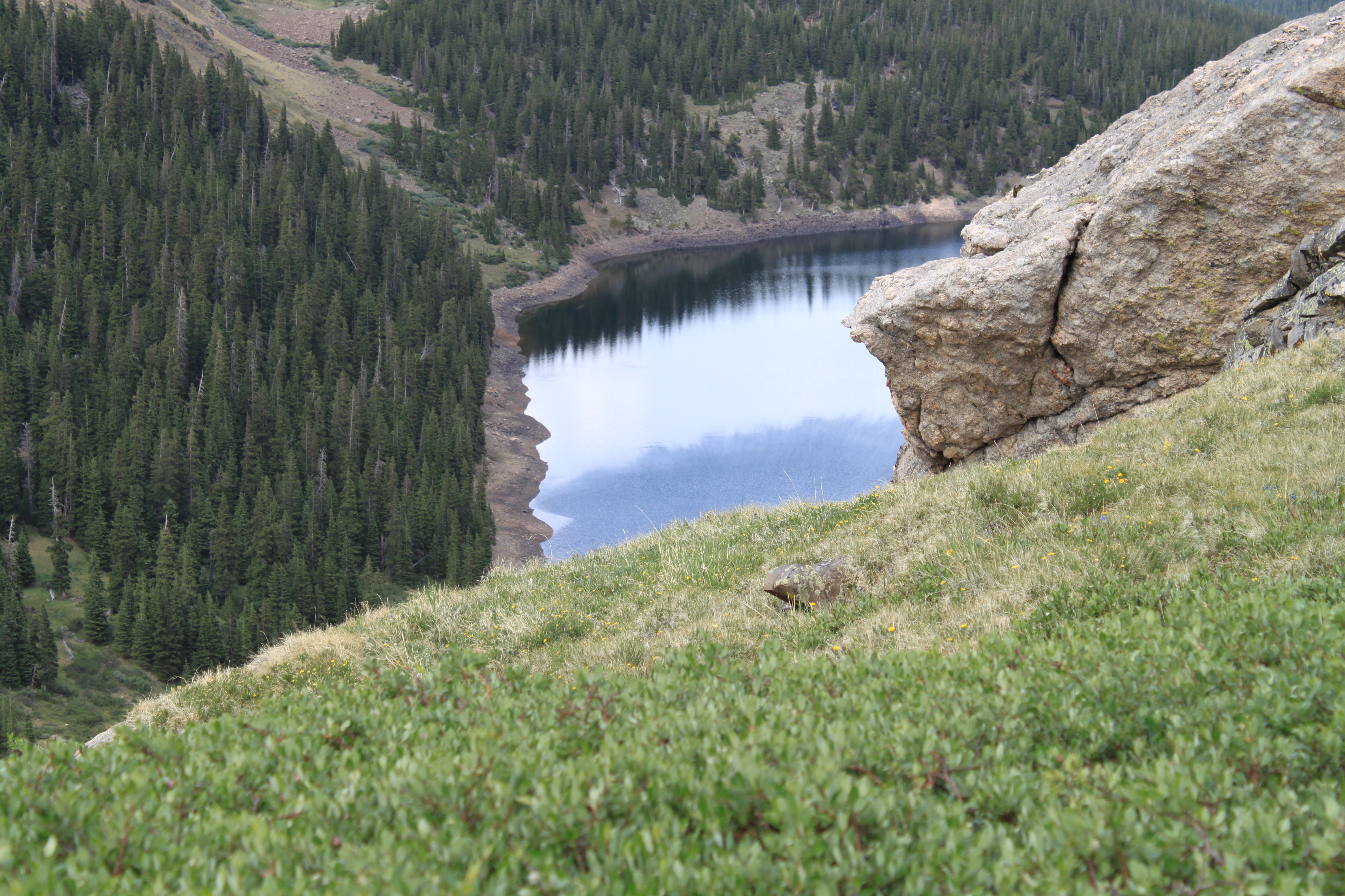
Shelf Lake

The trail to shelf lake is 3.4 miles with 1900 feet of elevation gain. This is a substantial effort even without a pack, and approaches the limit of how far we'd realistically want to carry an iSUP. That said, on the right days Shelf Lake is a stunning escape from the mid-summer heat.
 |
| Alpine SUP |
 |
| SUP Captain |
The trailhead to Shelf Lake is at the far end of Geneva Park. Geneva Park is the beautiful--if unexpected--valley halfway up the south approach to Guanella Pass. To access, turn west on Forest Road 119, which is marked by signs for the Geneva Creek and Duck Creek recreation sites. Follow Road 119 for 2.9 miles to an obvious trailhead, passing 30+ designated roadside campsites en route. The Shelf Lake Trailhead also serves South Park Trail. Some maps, like older editions of the Latitude 40 Summit County Map, still show the Shelf Lake Trail starting from further west on road 119 as it formerly did. The COTREX map accurately depicts the current trail routing, with Trails 663 (Shelf Lake) and 600 (South Park) diverging a couple hundred feet north of the shared trailhead.
 |
| Shelf Lake from trail |
The Shelf Lake Trails starts out gently for the first 0.6. It climbs more aggressively in the next 1.3 miles to reach Smelter Gulch, which leads up toward the lake. The short segment between 10,600 and 10,800 is very steep. Above that, the trail ascends moderately for 1.7 miles to the head of the basin, followed by a steep 0.4-mile push to Shelf Lake's perch. The lake itself is peanut-shaped, with a lobe that bends rightward behind a prominent knob next to the lake. From the water surface, Shelf Lake has an exciting vista across Smelter Gulch toward the west face of Square Top Mountain.
 |
| Shelf Lake Vista |
Other area adventures
Mt. Bierstadt is probably the most popular destination on the Guanella Pass Road, and understandably so. It is a 14,000-foot peak that is close to Denver, easily accessible, and has a well-established route to its summit. Summer weekends can see a discouraging number of vehicles at the trailhead and parked on the roadside. Even pre-dawn or weekday attempts have enough visitors to make solitude seem hopeless. But there is another way...
Bierstadt's most unappreciated attribute is that the entirety of its route from Guanella Pass is above treeline. Why is this relevant? Because it makes the Bierstadt trail navigable with sufficient moonlight. Obviously, moonlight is weather dependent, but some mid-summer nights are warm, calm, and clear enough to be hospitable even above treeline. While the full moon seems like the obvious choice, it really doesn't climb high enough above the eastern horizon for good illumination until 10 pm or so. The sweet spot is waxing gibbous moon, 2 to 5 days before the full moon, which provides 80-90% of the illumination but is already high in the sky at dusk. Really...it's a legit hack and it happens for a few nights in each of the summer months.
 |
| Typical alpine flora |
 |
| Local alpine landscape |
The Burning Bear/Abyss Trailhead is located on Guanella Pass Road at the South end of Geneva Park. Abyss Trail is a popular hiking portal to the interior of the Mt. Evans Wilderness, although Abyss Lake itself is probably too far to feasibly carry an iSUP. Burning Bear is a mellow, mostly forested trail that skirts Geneva Park, and also serves as a medium-quality mountain bike ride.
.JPEG) |
| Hiking above treeline |
 |
| Allow time to pack up! |
Weather and Safety Considerations
The alpine lakes described above only see a few dozen hospitable days each year. Even in mid-summer, cold fronts and afternoon storm can sweep in miserable, dangerous conditions. This is one of those areas that really warrants a close look at the hourly and text forecast, not just the extended. Be sure to pick to approximate location from the pinpoint forecast map for the most accurate assessment. A default forecast from the nearest town can look a lot rosier than the actual weather at 12,000 feet. A precipitation chance over 20% or wind speeds over 10 is probably a no-go. But the hourly forecast will drill down on what time window is most accommodating.
 |
| Ice in July |
 |
| Very cold water! |
The most serious safety hazard above treeline is probably lightning. None of these lakes have a good view of incoming weather from the west, and all require an appreciable amount of time to retreat to relative cover from the trees below. Thunderstorms can also bring very cold torrential rain or hail. Not fun. All of these lakes have very cold water all season, so wear a PFD at all times.
 |
| Shelf Lake |
Effort and risks aside, the alpine terrain of Guanella Pass can offer a fantastic escape from summer's heat on sweltering, stale days. These adventures can border on Type 2 fun, but with a blissful, relaxing reward. Plan carefully, don't be afraid to bail, and wear your PFD!
No comments:
Post a Comment