
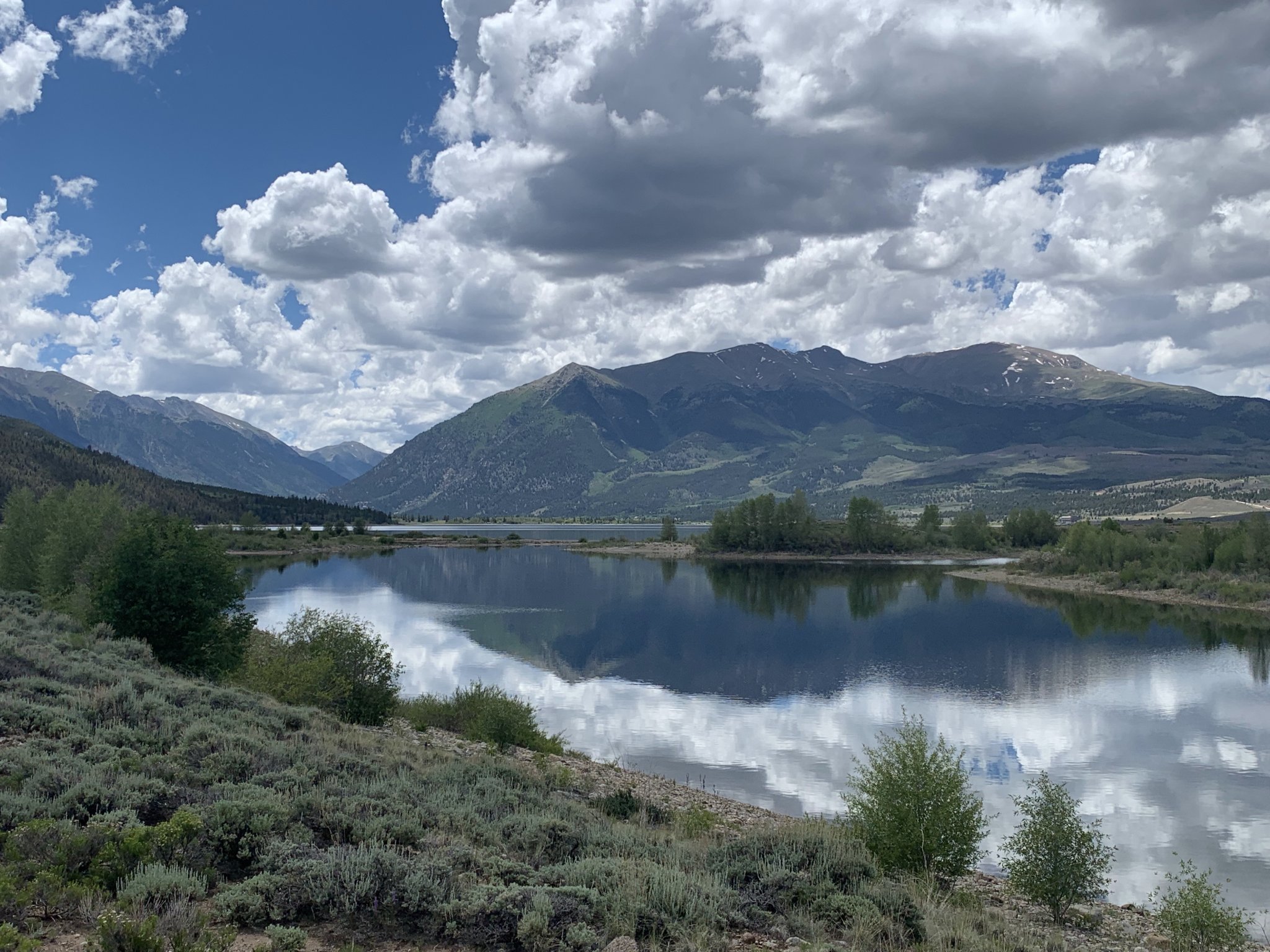
Twin Lakes is a well-recognized Colorado landmark that sits beneath the lofty Sawatch Range at the eastern gateway to Independence Pass. A mountain backdrop of Twin Peaks and Mt. Hope makes Twin Lakes a popular subject for landscape photographers, particularly during the autumn color change.
 |
| Twin Lakes Vista |
The Sawatch Range rises abruptly from the sagebrush uplands of the Arkansas Valley, through mixed conifer and aspen forests to the rocky tundra of Colorado's tallest peaks. Mountain vistas like this are typical of the Upper Arkansas Valley, which also contains Clear Creek Reservoir and Turquoise Lake. All three of these locations are easily accessible from U.S. 24, with only a few minutes gravel or dirt road driving from the highway. As far as stand-up-paddle places go, the region's best attributes are the scenery, pleasant summertime temperatures, and a plethora of nearby camping and recreational opportunities. A couple hours of paddleboard time can make a great addition to a camping, mountain biking or fourteener climbing trip in the area.
 |
| Vicinity Map |
(East / Middle / West)
Scenery: 4 / 4 / 4
Shoreline Interest: 3 / 2 / 2
Use: Moderate-high / Mod. / Mod.
Fee: Varies
Access: Gravel
Full elev = 9190; water level
Rec. info: East / Middle / West
Weather
(Scroll down for Clear Creek, Turquoise info)
Shoreline Interest: 3 / 2 / 2
Use: Moderate-high / Mod. / Mod.
Fee: Varies
Access: Gravel
Full elev = 9190; water level
Rec. info: East / Middle / West
Weather
(Scroll down for Clear Creek, Turquoise info)
Twin Lakes
Despite its name, Twin Lakes is actually a single, contiguous body of water. The two basins of the lake are naturally occurring, but a modest dam on the east side creates a slight increase in the lake's full elevation and footprint. Both halves are quite large, but the inlet and outlet areas have some interesting features that make good paddleboarding waters.
East End:
A quick glance at an aerial image of the east end of Twin Lakes reveals some intriguing topography. The small labyrinth of irregular-shaped islands and interlinking channels looks like inviting terrain for stand-up paddleboarding--and it is! The islands appear to be remnants of glacial moraines--deposits of glacial till scraped by the immense weight of snow and ice up-valley and left as mounds at the toe of the basin. Uniquely, three of these islands wrap around lagoons in their interiors. These interconnecting channels are relatively shallow and well-protected from waves of the main lake. Beyond the islands, there are broad shallows at the southeast corner of the lake that tend to harbor warmer water than the lake's deeper areas.

.png)
There are a lot of dispersed camping sites at the east end of the lake. There is also a maze of dirt roads that may cause confusion when trying to reach the water's edge. The best way to navigate this area is to take a screenshot of the aerial map. In addition to several waterside camping areas that can be used for launching, there is also a small day use parking area that is conveniently located on a narrow spur channel that leads to the lake. The day use parking is marked on the map below. To drive to this area, fork right from County Road 25 before the two formal Colorado Trail and Interlaken trailheads and instead wind down through bumpy dirt roads to a large, informal Interlaken trailhead. Water access is in the trees just beyond, with a route marked on the map below.
Middle:
Deception Point fishing site accesses the area where the two halves of Twin Lakes connect. A short channel cuts through the peninsular moraine that separates the two lake basins. The channel may have a small west-to-east current. The historic Interlaken Resort is at the southwest corner of the eastern lake, about 0.6 miles south of the connecting channel. A lagoon northeast of the channel has additional mellow waters to explore depending on lake level.
West End:
The main feature at the west end of Twin Lakes is the Lake Creek delta. This area has expansive shallows and it harbors calmer water than the rest of the lake during a westerly breeze. The west end of the lake is best accessed from the Moache Fishing Site.
 |
| Paddling on Twin Lakes |
 |
| ☆ Another of Twin Lakes' lagoons |
Nearby hiking and biking
Interlaken Trail is a great excursion that follows the south shore of Twin Lakes, passing the historic resort site of Interlaken. This mellow trail is good for both hiking and mountain biking. The Colorado Trail also skirts the north and east sides of Twin Lakes. Both the north and south adjacent segments of this exceptional hiking trail are also good for mountain biking. For the southern segment toward Clear Creek, follow County Road 25 to the obvious trailhead just beyond the dispersed camping area. The northern segment to Halfmoon Creek can be accessed here also, but a closer starting point is the South Mt. Elbert Trailhead--3 miles west on CO-83 and 1.3 miles up County Road 24.
In addition to the dispersed camping area at the east end of the lake, developed forest service campgrounds can be found at Dexter (north shore; east bay), Whitestar (north shore; west bay), and Lakeview (hillside north of CO-82). Whitestar and Lakeview offer reservations on recreation.gov.
 |
| Clear Creek Reservoir, looking west |
 |
| Clear Creek Reservoir, looking southeast |
Clear Creek Reservoir
Clear Creek Reservoir fills the eastern end of a classic Sawatch Range valley that is very popular with 14er hikers. A total of five 14,000-foot summts (Oxford, Belford, Missouri, Huron and La Plata) are accessible from the Clear Creek Valley, as well as many others (Emerald, Iowa, Ice) that don't quite reach 14,000 feet but are far less popular. When conditions are good, an afternoon paddle on Clear Creek Reservoir can be a great way to relax after an ascent of one the surrounding peaks. It is notably smaller than Twin Lakes, but still large enough to have choppy waters on breezy days. Access points are pretty obvious from the main road (County Road 390), and the easiest ones are marked on the map above. There is limited camping in the immediate vicinity of the lake; many more campsites can be found scattered further west up the Clear Creek Valley. Clear Creek Reservoir is a State Wildlife Area, so as SWA Pass or valid hunting or fishing license is required to access the site.
 |
| Classic Sawatch Range Backdrop |
Location info: [key]
Location info: [key]
Turquoise Lake (East / West)
Scenery: 3 / 3
Shoreline Interest: 2 / 1
Use: Moderate-high / Moderate
Fee: $7/day use; $24/camping
Access: Gravel
Full elev = 9869; best near full
Shoreline Interest: 2 / 1
Use: Moderate-high / Moderate
Fee: $7/day use; $24/camping
Access: Gravel
Full elev = 9869; best near full
Water level
Rec. info: East / West
Weather
Rec. info: East / West
Weather
Turquoise Lake
At four miles in length, Turquoise Lake is a vast body of water without a lot of small coves or shoreline features. Its best attributes for stand-up paddleboarding are its scenic location and the lakeside camping that's available on it eastern shores and western inlet. For these reasons, it serves better as a shoreside base camp while recreating in the area than a paddle-specific destination.
East Shore:
Of the half-dozen campgrounds on the east shore of the lake, Baby Doe, Belle of Colorado and Molly Brown have sites at the lake's edge. Of these, Baby Doe and Molly Brown have reservable sites on recreation.gov. Not all sites are on a loop next to the lake; the ones that are tend to get reserved well in advance. For campsites that are further from the shore, or for day use, the Lady of the Lake/Tabor ramp is an easy launch point on the corner of the lake. Since there is a lot of wind exposure distance across the length of the lake, waters in this area may be choppy and unpleasant during the day. But a lakeside campsite gives quick access to the water when conditions are calm, like mornings and evenings.
West End:
The west end of Turquoise Lake is tapered and narrower. Another lakeside campground (May Queen) with reserve-able sites is located at the Lake Fork inlet into the reservoir. There is a boat launch right next door at Butcher Boy day use area. Steeper slopes and a few shorelines coves makes the west end of the lake more interesting than the eastern side. It is also more protected unless the wind is blowing from the east.
 |
| Classic Sawatch high country |
 |
| Mining Ruins on Emerald Peak |
Nearby hiking and biking
The mellow, 6.4 mile Turquoise Lake Trail follows the north and east shores of the lake through predominantly lodgepole pine forest. It is suitable for both hiking and biking. Just west of the reservoir are hiking trails to Timberline Lake (2.2 miles) and Windsor Lake (1.1) miles. These are hiking-only trails that cross into the Holy Cross and Mt. Massive Wilderness Areas, respectively. A little further up the Hagerman Pass Road is another hiking/biking trail that follows an old railroad grade past trestle remnants to the abandoned Hagerman Tunnel under the continental divide. Turquoise Lake also serves as a decent base camp when hiking Mt. Elbert or Mt. Massive--the two highest summits in Colorado.
Wherever you decide to adventure in this exciting region, look for some time on the water. Watch for wind and thunderstorms on the hourly forecast for these large lakes. Have fun, wear a PFD and stay safe!
No comments:
Post a Comment