
...without having to travel there and see for myself...
It's always nice to know ahead of time if favorite paddleboarding places are at their high-water mark, or if they have a bathtub ring of dirt and gravel. Some of Colorado's most popular lakes have frequently updated, or even real-time reports on water level readily available online. Barr Lake is not one of them. What's more, a few feet of rise or drop in water level can be a whole world of difference in paddling experience.
 |
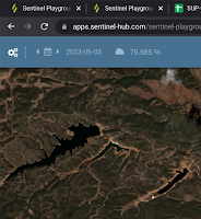
| Barr Lake nearing high water in April 2023 |
So, how to find out the current conditions at Barr Lake? Introducing Sentinel Playground...:
Sentinel Hub is continually updating database of satellite imagery and its Playground app is a free, easily accessible viewer that is available for casual users. The resolution of the imagery on Sentinel Playground is lower than what is displayed in Google Maps, but it is more than adequate to discern approximate water levels.
The most exciting feature of Sentinel Playground is the frequency if imagery updates. The calendar button in the upper left corner (right side on mobile) allows the user to select any date with available imagery. As denoted by circles on the calendar, there are updates every few days! If the selected day is cloudy, just skip backward or forward a few days and try again.
 |
| [screenshot: apps.sentinel-hub.com] |
 |
| [screenshot: apps.sentinel-hub.com] |
So what are some other applications of Sentinel Playground to planning paddleboard outings? Here are a few examples of times we've referenced Sentinel Playground to learn more about paddle conditions:
- To see water levels in the early season
- To see when high water levels inundate tree areas
- For alpine lakes, to determine if there is ice on the water
- To predict future water levels based on previous years
- For lakes with seasonal fluctuations, to estimate when they will completely fill
Here are some popular places without water level updates where Sentinel Playground can be useful to discern conditions.


 | |
|

 |
| Pikes Peak N. Slope [screenshot: apps.sentinel-hub.com] |
 |
| Rampart Reservoir [screenshot: apps.sentinel-hub.com] |
The above links should open up a viewing window around the named location, but the imagery will not be current. Just click the calendar button and select a current-ish date without clouds. Also, the settings with coloration option opens up by default. It can be easily minimized to expand up the viewing window by clicking on the arrow in the upper left.
Another fun time-waster with Sentinel Playground is to surf back in time and check out imagery from months and years past. This is especially interesting on reservoirs that see lots of fluctuation and complex shorelines--like Powell or Dillon. One of our favorite observations is how Farley Canyon has barely changed over the past several years even as Lake Powell has dropped precipitously. Meanwhile, neighboring White Canyon has undergone dramatic change after becoming disconnected from Lake Powell and bisected by sedimentation. It would also be interesting to see how flood control facilities like Chatfield or Cherry Creek or Bear Creek inundate after a significant rain event such as the September 2013 floods.
 |
| Farley & White Canyons - June 2019 [screenshot: apps.sentinel-hub.com] |
 |
| Farley & White Canyons - April 2023 [screenshot: apps.sentinel-hub.com] |
Sentinel Playground is an exciting tool that is both useful and fun. Hopefully it can help in planning excursions to paddle places during their prime conditions. Have fun and stay safe!
No comments:
Post a Comment