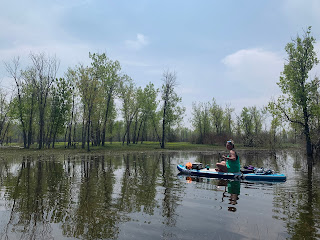
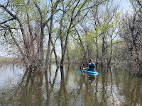
On average, May is Denver's wettest month. But May of 2023 was one for the recordbooks! During a multiday soaking event, Denver officially recorded 4.9 inches of rain that caused streams to swell and reservoirs to rise. Cherry Creek Reservoir, in particular, saw a dramatic impact from the surge of rainwater. The resulting inundation of the southern shorelines made for a novel paddleboarding experience. For some backstory, continue reading; to skip to the paddling, click this link to our Cherry Creek Reservoir post.
Cherry Creek Dam is one of the three units the make up up the U.S. Army Corps of Engineers' Tri Lakes Project. The other two elements are Chatfield and Bear Creek. Together, the three structures protect Denver from flash floods that could threaten the city during prolonged periods of widespread rainfall upstream. When significant rain events occur, the dams constrain outflows and reservoir levels rise. During the May 2023 storm, the water level in Cherry Creek rose 10 feet. The water level of Chatfield rose 7 feet. The water level in Bear Creek rose 28 feet!
High water levels make the reservoirs swell and inundate low-lying areas along the shoreline. If the topography is flat-ish, the backwater can extend hundreds--even thousands--of feet beyond the normal shoreline. When the flooded areas are thickly forested, as is common along inflowing streams, wonderful paddleboarding adventures await in the shady waters beneath the trees. Fortunately, most of the mature trees that grow along streambeds are tolerant of short periods of flooding. The September 2013 floods left a black band of rotting foliage about 30 feet high across all of Bear Creek's trees. But within a couple years the forest appeared pretty much back to normal.
Cherry Creek, Chatfield and Bear Creek Reservoirs are all designed to flood on occasion--sometimes dramatically. Since all three were are built as flood control facilities, each lake's normal operating water level is well below the crest of the dam. This is why all three dams appear as hulking masses from the water surface. But that enormous volume between the recreational water surface and the dam crest is the amount of floodwater that the reservoirs could impound before the surge of runoff would threaten Denver. Chatfield, for example, is normally filled to about 8% of it's total capacity. The other 92% is cushion for flood protection.
 |
| Cherry Creek Res. (05/08/2023) [screenshot: apps.sentinel-hub.com] |
 |
| Cherry Creek Res. (05/16/2023) [screenshot: apps.sentinel-hub.com] |
Interestingly, Clear Creek--which has a larger watershed than either Bear Creek or Cherry Creek and also flows through a highly populated area--doesn't have any flood control structures on it. Perhaps this is because Clear Creek's runoff bypasses Denver on the north, or because there was far less population along Clear Creek when the projects were commissioned in the 1940s.
 |
| Temporary lagoon on Cherry Creek's southeast shore |
For a separate non-paddling excursion, visit Castlewood Canyon State Park near Franktown. In addition to some great hiking and climbing routes, the park contains the remnants of a dam that pre-dates Cherry Creek Reservoir. A failure of the Castlewood Dam in 1933 sent a destructive torrent of water down Cherry Creek, through central Denver and beyond. The 1933 flood is exactly the type of catastrophe that today's reservoir is designed to prevent.
 |
| Ruins of Castlewood Dam |
 |
| Inundated meadow |
Watercraft aren't always allowed in surcharged reservoirs after significant floods. Sometimes motorized boats are prohibited but hand-launched crafts are permitted. When paddling around in high waters after a big storm, there are additional hazards that aren't present in normal conditions, including the following:
- Floods wash LOTS of debris in streams and lakes, including large, broken branches with sharp edges.
- With a current or wind, it is much easier to get tangled in or pinned by a debris pile.
- There are LOTS of hidden hazards under the surface, like sharp, stationary tree branches. Go slow.
- Snakes! They can be disturbed by flood waters and are more likely to be seen swimming among the trees.
- Flood waters are usually quite murky.
- Flood waters also pick up a lot of contaminants. Best to stay out of the water and to leave pets at home :(
Another effect of significant rain events is that they pick up lots of trash! Items that may have sat idly for months or years suddenly get dislodged from storm runoff and carried downstream. The bad news is that all that garbage gets dumped into lakes like Cherry Creek and drifts to the shores. The good news is that if you're prepared with a trash bag, it can make for a really productive cleanup effort. No one likes to find a piece of garbage in the wild, but it's empowering to be the last person who ever has to see it!


No comments:
Post a Comment