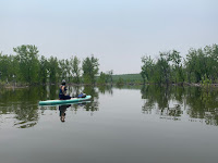
Bear Creek Lake is one of metro Denver's most inviting paddleboard places when conditions are good. Despite the massive size of the dam that impounds it, the lake is fairly compact. Its shoreline is interesting, with areas of trees and grassy shallows, and it is small enough that it doesn't get overrun by wind. Furthermore, motorized boats are limited to 10 horsepower.
But Bear Creek's superpower is an obscure one. The reservoir sees higher fluctuations above the normal water level than any lake in the region. Above is the operative word here, because a rise in the water level means that the lake surface expands beyond the established shoreline. And when there are lots of trees around the lakeshore, it creates a wonderful, shady overlap of lake and forest.
Bear Creek is not the only lake that sees periodic intrusion of water into forests. Chatfield, Barr, Horsetooth and Cherry Creek all have areas of glade paddleboarding from time to time. But the magnitude of lake level rise blows those other places out of the water (so to speak). For example, heavy rains in May of 2023 caused the water level to shoot up 28 feet and doubled the reservoir surface areas from 92 acres to 200. The September 2013 floods spiked the lake level 60 feet and swelled the water surface to 400 acres.
 |
| Bear Creek Lake (05/03/2023) [screenshot: apps.sentinel-hub.com] |
 |
| Bear Creek Lake (05/23/2023) [screenshot: apps.sentinel-hub.com] |
Cottonwood trees play an important role in Bear Creek's magic. They are large, grassland trees that thrive in streambeds where the water table is close to the ground surface. The cottonwoods are also quite tolerant of occasional flooding that occurs along rivers and, incidentally, around flood-control reservoirs. The widespread resilience of Bear Creek Lake cottonwoods, some of which were inundated up to two thirds of their height during the 2013 floods, is an impressive feat of nature. Most of these trees are still standing, happily providing shade on the water after 2023's flood surge nearly ten years later.
 |
| Poking through Bear Creek's woodlands |
Depending on how high the water has risen, the logistics of paddling on Bear Creek Lake may be a little trickier than usual. The lake's normal access locations--the North Boat Ramp and Lower Pelican Point--become flooded with even a modest rise in water level. When this happens, it may be necessary to carry equipment a moderate distance to the water's edge from the nearest open staging area. If the Lower Pelican and the north ramp are closed, try Upper Pelican for the south shore or Whitetail for the north. Parking is not always permitted where it's convenient; be sure to park in a designated lot.
As exciting as Bear Creek can be during periods of high-water, its future may see some drastic changes. The U.S. Army Corps of Engineers--the owner and creator of Bear Creek Lake--has been studying the possibility of re-allocating some of the lake's available volume from flood control to storage. A slew of options are being evaluated--including a no-action alternative--but a few of the options are quite disruptive. The boldest idea considered is an expansion of the lake's normal operating storage by 20,000 acre-feet. This would cause a semi-permanent raise of 65 feet to the water level, drowning out 70 acres of trees and wetlands and flooding several hundred more acres of scrub and grassland. Since the water would be retained for storage, instead of released upon abatement of flood risk, the inundated areas would not be able to recover as they do today. Seasonal drawdown would also leave a bathtub ring with broad mud flats, sort of like Horsetooth sees after sequential drought years. Also lost would be many miles of hiking and biking trails that wind through the riparian terrain along Bear and Turkey Creeks.
 |
| Inundated Meadow, May 2023 |
For the record, the City of Lakewood and Town of Morrison have officially adopted positions favoring minimal disturbance to the existing park space. Lakewood has also quantified the impacts to recreational resources under a range of expansion scenarios for Bear Creek Lake. For hikers and bikers who frequent the trails that wind through the park, the extent of the possible impacts can be startling. Part of the feasibility study process involves solicitation of public comment, which should be directed to the U.S. Army Corps of Engineers (Bear-Creek-Study@usace.army.mil). More information on the specifics of the proposals, impacts to the park, and the arguments against expansion are available from the Colorado Water Conservation Board, City of Lakewood, and Save Bear Creek Lake Park, respectively.
It is quite possible that Bear Creek Lake will continue to function in its role as a flood-control facility for the foreseeable future. Or maybe it won't. But in the present day, it's a fascinating, exotic stand-up paddle place! Always take extra care when the water levels are elevated. There are underwater hazards, large floating objects, and even snakes that may swim across the water (yes, we've witnessed this). Also be conscientious of currents from inflowing streams that can trap or pin against objects in the water. The currents may persist into broad stretches of inundated woodlands, and the stream paths aren't always obvious. Have fun, stay safe, wear a PFD, and enjoy the fantastic place that Bear Creek Lake can become after heavy rains.


No comments:
Post a Comment